

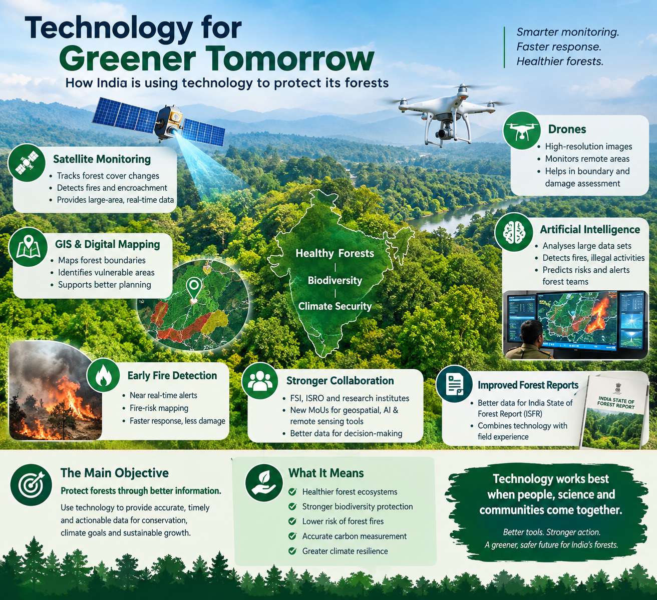
Forest conservation in India is entering a technology-driven phase, with satellite imagery, geographic information systems, artificial intelligence, drones and digital databases increasingly being used to understand, monitor and protect the country’s natural resources.
The latest push came into focus at a national workshop on leveraging new technologies for the assessment of forest and tree resources, where Union Environment Minister Bhupender Yadav called for greater use of technology to improve forest monitoring, data quality and conservation planning.
The message is clear: technology is no longer simply a tool for measuring forest cover. It is becoming an important part of how forests are protected, how threats are detected and how climate commitments are monitored.
The Main Objective: Protect Forests Through Better Information
The primary objective of technology-based forest conservation is to provide accurate, timely and actionable information.
Forests cover vast areas, including remote and difficult terrain where conventional field monitoring can be challenging. Satellite imagery and digital mapping can give authorities a much broader picture of changes in forest cover, land use, fire activity and ecological conditions.
The Forest Survey of India already uses remote sensing, GIS, forest inventories and decision-support systems as part of its forest assessment work. Its systems provide information on forest resources and support monitoring by state forest departments.
The goal is to make conservation decisions based on stronger evidence rather than relying only on periodic surveys.
Satellite Technology Is Becoming the Eyes of the Forest
Satellite-based monitoring is one of the most important technologies being used in forest conservation.
India’s Forest Survey of India operates systems that use satellite sensors to detect forest fires and provide alerts to forest officials. Data from MODIS and SNPP-VIIRS satellites is processed to generate near-real-time fire alerts, helping authorities respond more quickly.
This can be particularly important during periods when dry conditions increase the risk of forest fires.
Satellite monitoring can also help authorities observe changes in forest and tree cover over time, identify vulnerable areas and support restoration planning.
Technology Can Help Fight Forest Fires Before They Spread
Forest fires can destroy vegetation, wildlife habitats and carbon stored in biomass. Early detection therefore remains one of the biggest opportunities for technology.
The Forest Survey of India’s forest-fire systems provide near-real-time monitoring, early-warning alerts and fire-risk information. Large forest fires can also be tracked continuously using satellite data.
This allows forest departments to move towards a more preventive approach.
Instead of waiting for a major fire to become visible on the ground, authorities can receive information about potential hotspots and deploy teams to vulnerable locations.
FSI’s current systems also include fire-danger ratings and identification of fire-prone forest areas, helping officials focus resources where the risk is higher.
AI Adds a New Layer of Protection
Artificial intelligence could take forest monitoring a step further by analysing large volumes of satellite, camera and sensor data much faster than traditional methods.
Recent government material has highlighted the use of AI and machine-vision systems to analyse real-time camera footage around forests. Such systems can help identify forest fires, illegal activities, encroachment and situations that could lead to human-wildlife conflict.
This creates the possibility of a more intelligent early-warning system in which technology can identify unusual activity and alert forest personnel before a problem becomes more serious.
Drones Can Help Reach Difficult Forest Areas
Drones offer another useful layer of surveillance.
They can provide high-resolution images of areas that are difficult for forest teams to access regularly. This can help in monitoring forest boundaries, checking plantations, observing damaged areas and supporting field investigations.
When drone information is combined with satellite data and ground observations, authorities can obtain a more detailed picture of what is happening within a forest landscape.
India Is Strengthening the Technology Ecosystem
The technology push is not limited to one department or one type of tool.
In March 2026, the Forest Survey of India and the Bhaskaracharya National Institute for Space Applications and Geo-informatics signed an MoU to strengthen the use of geospatial technology, remote sensing and AI/ML-based tools for forest-fire management, wildlife conservation and decision-support systems.
In another recent development, the Forest Survey of India and the National Remote Sensing Centre of ISRO discussed the use of enhanced fire products and NISAR data for forest-fire management and more precise estimation of above-ground biomass.
These developments show how India’s forest-conservation efforts are increasingly bringing together space technology, artificial intelligence, geospatial systems and ground-level forestry expertise.
Better Data Can Strengthen the India State of Forest Report
Another important objective is improving the quality of information used to prepare the India State of Forest Report (ISFR).
The report provides a major assessment of India’s forest and tree resources. Better satellite data, field information and digital tools can make forest assessments more detailed and useful for policymakers.
The latest discussions have emphasised the need to combine technology with field experience and develop stronger standard procedures for forest assessment.
This is important because technology can identify changes, but forest officials and local communities can provide valuable information about the reasons behind those changes.
Technology and India’s Climate Goals
Forest conservation is closely connected with India’s climate strategy because forests act as natural carbon sinks.
India has set an enhanced ambition of creating a 3.5-4 billion tonne carbon dioxide-equivalent carbon sink by 2035. Achieving such a target will require accurate measurement of forest carbon and better management of existing forests.
Technology can help estimate biomass and carbon stocks, monitor changes and identify areas where restoration efforts can have the greatest impact.
Recent work involving NISAR data and above-ground biomass assessment shows how advanced space-based observation could contribute to more precise carbon and forest-resource measurements.
Conservation Is About More Than Trees
A technology-based approach also needs to look beyond forest cover.
Wetlands, grasslands, wildlife habitats and other ecosystems are closely connected with forests and play important roles in maintaining ecological balance.
Digital mapping and geospatial technology can help authorities understand these connections and plan conservation at a landscape level rather than treating individual ecosystems in isolation.
This approach can also support biodiversity protection and help identify areas vulnerable to climate-related risks.
Technology Cannot Replace People
Despite rapid advances in technology, effective conservation will still depend heavily on people.
Forest officials need training to use new tools effectively. Scientists and technology companies need to develop solutions suited to India’s diverse ecosystems. Local communities also have an important role because they often possess detailed knowledge of forest conditions and seasonal changes.
The most effective model is therefore likely to be a combination of technology, scientific expertise, government institutions and community participation.
From Monitoring to Prevention
The biggest change technology can bring to forest conservation is a shift from simply recording damage to preventing it.
A satellite can identify a fire. AI can analyse a suspicious pattern. A drone can provide a closer view. GIS can identify the location. Field teams can then take action.
Together, these technologies can create a faster chain from detection to decision and from decision to action.
The Road Ahead
India’s growing use of technology in forest management reflects a broader shift towards data-driven environmental governance.
The objective is not to replace traditional conservation practices but to make them smarter, faster and more precise. With better satellite monitoring, AI-based analysis, digital mapping, drones and stronger field networks, India can improve its ability to protect forests, conserve biodiversity, manage fires and monitor carbon stocks.
Ultimately, the success of this technology-led approach will be measured not by the number of digital systems created, but by whether those systems help keep forests healthier, ecosystems more resilient and communities better protected.